Tillamook Birder
  • Home
  • Where to Bird
    • Outer Coast
    • Tillamook Bay
    • Estuaries, Lowlands, Other Bays
    • Coast Range
  • Calendar
    • Jan - Feb
    • Mar - Apr
    • May - Jun
    • Jul - Aug
    • Sep - Oct
    • Nov - Dec
  • Sightings
    • Recent
    • Statewide
  • Resources
    • Tillamook CBC
    • Conditions
    • Lists
    • Publications >
      • Reed Ferris' 1930-1943 bird banding records and bird observations for Tillamook County, Oregon
      • Habitat Conservation Plan for the Western Snowy Plover
      • Cascade Head Scenic Research Area Management Plan
      • Nestucca Bay NWR Final Comprehensive Conservation Plan (CCP)
      • Tillamook Estuaries Partnership’s Tillamook Bay Comprehensive Conservation and Management Plan (CCMP) >
        • 2012 Fall NAMC
      • Species of Concern of the Tillamook Rainforest
      • 2011 Birding and Blues (David Irons) >
        • Tillamook County "Big Day", Feb 2012
      • Tillamook Bay Watershed Health Report 2010
    • Tillamook County >
      • Tillamook (John Rakestraw, 2012)
    • Topo Maps
  • Photo Gallery
    • MAK Gallery >
      • MAK Photos from Elsewhere
    • JE Gallery
    • KC Gallery
    • dv Gallery
    • b-j Gallery
    • JB Gallery
    • Other Photos
  • Links
  • TillamookBirderBlog
  • Contact

Tillamook County Conditions and Alerts


  1. ADVISORY! Highway 101 and many other roads closed in parts of Tillamook city and other parts of the county. Road status information... 
  2. ALERT! Closure of Three Cape Scenic Route just north of Cape Meares. Closure is indefinite due to active landslides. More information...

Gordon's Tillamook Weather Center
  • Current conditions, including rivers, roads, weather, etc. 
  • Check out Gordon's Facebook weather page for current updates and other information
Mesonet Observations (NOAA)
  • Dynamic map with links to Oregon environmental monitoring stations
  • Current winds, temperatures, etc.
Hydrology Predictions (NWS)
  • Dynamic map with links to Oregon streamguages, current conditions
  • Also see Oregon River Levels (right)
Oregon River Levels
  • Also see specific River Conditions links below
Tillamook County Emergency Management
  • News alerts from multiple agencies (Nixle service) 
Tripcheck
  • Road and travel conditions
  • Highway 6 webcam

Siuslaw National Forest Current Conditions
  • Trail and travel conditions
  • Weather
  • Special alerts

Tillamook State Forest Current Conditions
  • Wilson River webcam
  • Forest Center webcam
See "Coastal Conditions" links below for more complete Weather information; or use the links that are provided for most of the Birding Sites.

Picture
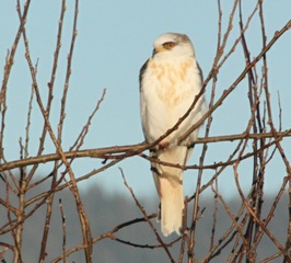
White-tailed Kite (juv) -- Photo: dawn villaescusa

Monthly Tidal Predictions

NOTE: below are links to Protides.com tidal predictions. See Coastal Conditions below for links to NOAA sites.
  • North Tillamook Coast: [Nehalem] - [Brighton] 
  • South Tillamook Coast: Netarts, Netarts Bay
  • Central Tillamook Coast: Nestucca Bay entrance
  • Tillamook Bay: [Garibaldi] - [Barview] - [Bay City] - [Garibaldi] - [Miami Cove] - [Tillamook, Hoquarten Slough]

Coastal Conditions

Nestucca-Cape Kiwanda
  • Surf Conditions (with Weather and Tide)
  • Tidal Predictions
  • Webcam
  • Weather Station
Cape Lookout-Oceanside
  • Surf Conditions (with Weather and Tide)
  • Tidal Predictions
  • Webcam
  • Weather Station
Manzanita-Rockaway
  • Surf Conditions (with Weather and Tide)
  • Tidal Predictions
  • Webcam
  • Weather Station

River Conditions

General inland water resources
  • Northwest River Forecast Center, NW Oregon
  • Oregon Streamflow Conditions (USGS)
  • Tillamook Water Trails (TBNEP)
  • Boating (and Birding) with Paddlecraft (OSMB)
  • Oregon boating access sites (OSMB)
  • Legal use of Oregon's rivers and lakes [pdf]
Wilson River (Tillamook)
  • River information (NWS)
  • Flow forecast (NOAA)
Nehalem River (Foss)
  • River information (NWS)
  • Flow forecast (NOAA) 
  • Kayaking conditions
Wilson River (near Tillamook)
  • River information (NWS)
  • Flow forecast (NOAA)
  • Kayaking conditions
Nestucca River (near Beaver)
  • River information (NWS)
  • Flow forecast (NOAA)
  • Kayaking conditions
Trask River
  • River information (NWS)
  • Flow forecast (NOAA) 
  • Kayaking conditions
All photographs are the property of stated photographer and may not be copied or used without the photographer's written consent.
Please report broken links.  Thank you!
Proudly powered by Weebly